| Save The Franklin Battlefield, Inc | ||
|
|
||
|
Help us save more open Franklin battlefield land |
||
|
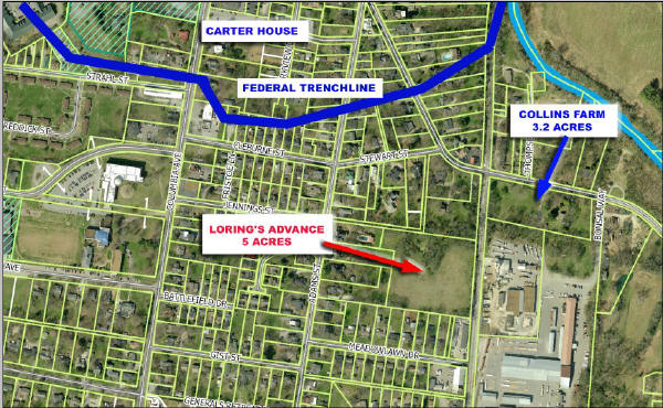
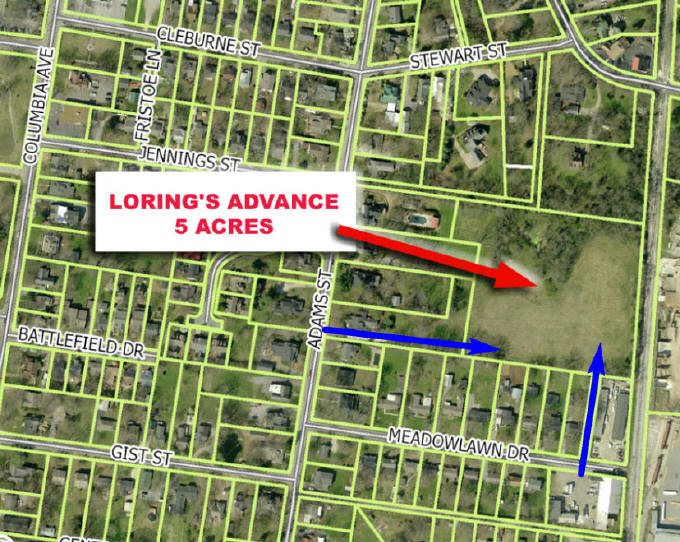
Location of Loring's Advance tract (in red). The Carter House is at upper left; Carnton is off the edge at bottom right.
|
||
|
November 5,
2011 - 10:00 AM -
First Ever Tour of Loring's Advance Our own incomparable Thomas Cartwright of Carter House and History Channel notoriety will lead the tour and tell of the determined and heroic soldiers who crossed this ground under terrible fire to reach the Federal line. Maps will be provided. We are certain that those who have closely followed the many preservation efforts here in Franklin will be thrilled to finally view the important terrain of this open 5 acres, and will quickly see how it can add to our collective understanding of the Battle of Franklin. These are truly exciting times for preservation efforts here in Franklin. We will see you at the tour ! Parking for the Tour - Please remember that we will have to cross private property to reach the Loring's Advance parcel, and we do so only with special permission beforehand. There are two options for parking for the tour shown by the blue arrows on the map below:
Questions on the tour - call (615) 500-6612 Keep reading below to learn more about the Loring's Advance parcel and how you can help us save this portion of the Franklin Battlefield.
|
||
|
Learn about Loring's Advance
For reference, the map at top of this page shows the Carter House at the northwest corner of the map and the extreme lower right corner shows the very northwest corner of the City’s Eastern Flank Battlefield Park (golf course). The distance between Carter House and Collins Farm is about 800 yards The Federal trench line runs along the north side of Cleburne and Stewart streets, then slants north to the RR tracks at the top of the picture. Loring’s division traversed this ground under fire during the November 30, 1864 battle. As Loring’s three brigades came north over the golf course to the river, the 4 ordnance rifles of the 1st Ohio Battery D at Ft Granger fired continuously into the crowded ranks. The four rifled guns fired 166 rounds and their post-war historian wrote that of all their actions during the war, their gunnery at Franklin that day was by far their most effective. As Loring's formations got stymied and jumbled at the river, they turned nearly 90 degrees left to cross Collins Farm. While realigning, they were additionally exposed to the 12 pounders behind the east end of the Federal line. Two of those Federal guns were then moved onto the RR tracks, probably near the Murfreesboro Road crossing, and fired double canister along the crescent curved track-bed and along the embankment on Collins Farm below the tracks where the Confederates took shelter. There is a ravine that slants southwest across Collins Farm to its corner boundary and continues along the north boundary of Loring's Advance. Today that ravine is blocked by a railroad fill and culvert. STFB Treasurer Sam Huffman postulates that as built and at the time of the battle, the railroad crossed that ravine on an open trestle. When Adams brigade was blocked by the human wreckage of the first two brigades to smash into the Federal line, he led his brigade west under the RR trestle and up the ravine. As they crossed under the RR, his men were temporarily sheltered in defilade from the Federal fires. As they reached the higher ground just beyond Adams Street, they were again exposed to savage converging fires from the entrenched Federal center. Adams then led a desperate, all-out assault into the main trench line east of the gin house where he was killed. The net result of this tragic day is that Loring's Division has more dead buried at the Confederate Cemetery than any of Hood's divisions - including Cleburne's. An 1878 Williamson County map seems to support the trestle idea. It shows that Lewisburg Pike did not bend left to cross the RR as it does today, but instead continues straight on southeast to the RR and then crosses (under??) the RR where the postulated trestle would be. More study of old land deeds is needed to confirm this idea. If found to be so, the trestle and the ravine on Collins Farm and Loring's Advance parcels become important terrain features to tell the heroic story of Adams Brigade. How you can help: STFB has committed to the Civil War Trust that we will raise $50,000 for the Loring's Advance purchase. Our November 5 tour marks the beginning of that campaign. We have received several pledges in recent months that will start the fund raising. First in line are our good friends of the UK CWRT in London, England under the leadership of Greg Bayne who pledged $500 for this purchase last spring, and have already sent the check. If you would like to help, please contact: Treasurer Save The Franklin Battlefield, Inc. PO Box 851 Franklin, TN 37065-0851
Related:
|
||
| © 1997-2023 Save the Franklin Battlefield Inc. | ||